Apologies to all who have been following my Directed Study blog posts and have realised I’m yet to write my fourth and final blog. Due to working on a dig here in the UK in a remote area, very limited access to the internet and a busy working schedule I have finally gotten around to completing the South Australian Archaeology Database and report.
The database project started way back in March, with the aim of creating a user-friendly and publicly available database of Indigenous archaeological sites located along the South Australian coastline. After several trips to the South Australian State Library, and hours spent looking through journals online, the archival research phase of the project uncovered 347 archaeological sites. The sites were found across the Adelaide Plains, Yorke Peninsula, Eyre Peninsula, west coast, Nullarbor Plain and Kangaroo Island.

Figure 1 – Example from Database
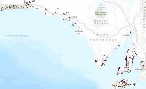
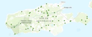
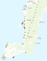
Once the database had been compiled and edited to a professional standard, the next phase of the project was to create a spatial distribution map in ESRI ArcGIS 10.1©.
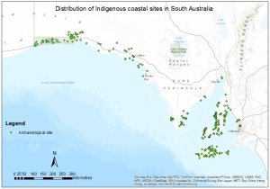
Figure 2 – Spatial Distribution Map of Sites
As the database and map were both being constructed, general patterns started to emerge in the data, which formed the basis for the analysis of the data. The aim of the analysis was to determine how South Australian Indigenous archaeology fit into the continental narratives of prehistoric Australia, and what the current gaps in the archaeological record of the region were.
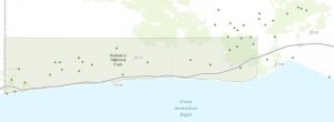
Using ArcMap and ArcCatalog software, site distribution patterns, proximity analyses in relation to site distances from the coast and water courses, environmental context investigations and colonisation model conformity based on dated sites were undertaken and revealed some intriguing and useful information on the archaeology of South Australia.
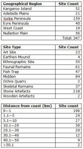
From the results, it could be seen that some site types were only found in certain geographic regions, while others, such as stone artefact scatters, were found in great numbers across the entire study area. Large proportions of sites were found to be within short distances of both the coast and of fresh water courses. Many sites were also located in protected areas of current-day land zones.
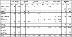
Figure 3 – Site types per geographic region
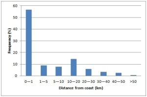
Figure 4 – Site frequencies and distances from coast
Only 12 of a possible 347 sites provided reliable dates, from which some minimal conclusions could be drawn as to how the study area fits into colonisation patterns, and more dates would need to be determined in order to make definitive concluding statements. The results disagreed with both Bowdler and Horton that settlement was along coastal areas before moving into central Australia, but conformed closely to Veth et al’s (2011) colonisation model of simultaneous settlement of all habitats through information exchange.
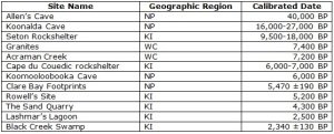
Figure 5 – Dated sites from project in chronological order
The database stands to be a key addition to the current archaeological record for South Australian archaeology as it has pulled together all the accessible publications available for the state into one, easy to use database. There were a large number of restricted survey reports and journal articles that would have helped to create a more complete database for South Australia, but this project has constructed a sound foundation to build upon.

