Author Archives: paddywaterson

“Hey Venus, Oh Venus”

Many of the younger readers may not be familiar with Franky Avalon and his 1959 hit song ‘Venus’, which contains a plea from a young man to the Roman Goddess of Love to help him find that elusive special someone (if you’re feeling nostalgic you can find him performing the song at: http://www.youtube.com/watch?v=fakpqLDEQAo). Much like the young soul yearning to discover love, we also went in search of Venus as part of the final leg of our magnetometer trials. The small snow-brig Venus made an unscheduled stop in Moreton Bay for supplies in 1855 while transporting sugar from Manila to Melbourne. The Venus attempted to enter the Bay without a pilot and took the wrong channel, foundering off the northern end of Moreton Island on a sand bank system that was subsequently named after the wreck.

A key issue for magnetometer survey was narrowing the search area. Historical research was conducted but sources were few, given the vessel was lost when Queensland was still part of the colony of New South Wales. Newspaper reports from the time did, however, provide quite detailed information on the events leading up to the wrecking, with some vocal critics stating that a missing navigation marker played a key role. In order to help refine the search area, archaeologists Amelia Lacey and Toni Massey liaised with Mr Ian Jempson, Chief Executive Officer of the Queensland Maritime Museum and a former naval navigator. The Queensland Maritime Museum holds copies of historic admiralty charts for Moreton Bay, which were digitised and then georeferenced by Amelia. Ian was able to cross reference the historic sailing instructions with the published account of the wreck’s position and develop a theory of where it is located now. The varying positions of the banks over time were also tracked on the charts.
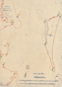
Image 1: A georeferenced copy of the 1846 navigation chart for Moreton Bay

Image 1: A georeferenced copy of the 1846 navigation chart for Moreton Bay

Not unexpectedly, there was a significant margin of error in the georeferenced charts and this resulted in a larger search area than hoped. To supplement the mapping team’s work I sought information about potential sightings of the wreck from public informants and marine parks staff.
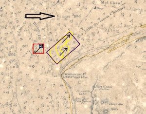
Image 2: The search area (marked by the larger box with yellow contours) for the wreck of the Venus superimposed on the historic chart. Note the name Venus Banks immediately above the search area.

Image 2: The search area (marked by the larger box with yellow contours) for the wreck of the Venus superimposed on the historic chart. Note the name Venus Banks immediately above the search area.

The team set out under clear skies but with a freshening breeze to begin the process of surveying the search grid. Alas, however, as tends to happen in affairs of the heart, there were soon problems when the magnetometer failed after the first transect. After some unsuccessful attempts to redeploy the fish, we realised that there was a connection problem and returned to base to switch to the shorter umbilical cable, which is normally used to link the mag with a towed side scan sonar – fortunately this was a very shallow site. Unfortunately, we had lost a lot of time and could not complete the planned search grid that day; we therefore decided that the best option was to run the mag past a target further to the east north east that was reported to us by two separate sources. The estimated position revealed an almost immediate positive return with the mag, but little was visible on the side scan. This site definitely needs to be investigated further, but to date we have been unable to return to the area as repairs to the mag and vessel availability have caused delays. Love remains elusive but we hope to resume our quest in the autumn of 2015 when the conditions are expected to be more favourable.

Discovering the already discovered – It’s OK to still be excited!

The problem with some maritime sites is that they are only intermittently visible, and relocating them once they are recovered can require the use of specialised equipment such as a magnetometer; especially if the area is physically changing and you lack precise coordinates. Relocating an elusive wreck often requires as much work as finding one that has never been sighted – but it’s rediscovery can be met with underwhelming responses of ‘so what –someone had already found it!’

As part of magnetometer trials being conducted by the Department of Environment and Heritage Protection (Queensland) we thought it would be beneficial to examine two similar wrecks off the Gold Coast to determine how comparative signatures could be used to locate obscured wrecks. The first wreck is that of the Scottish Prince, an iron barque of 850 tonnes that ran aground in1887 and is now a popular dive site. The second wreck, the Cambus Wallace, is an iron barque of 1650 tons that also ran aground, but is now quite collapsed and usually covered in sand. The two are often referred to as the whiskey wrecks, as they were both carrying large consignments of bottled whiskey which were heavily salvaged by helpful locals keen to clear the beach of debris.
EHP maritime archaeologists and rangers from the Department of National Parks Recreation Sport and Racing (NPRSR) went out under overcast but calm conditions and commenced the survey over the known location of the Scottish Prince wreck. The north south transects took in a wide area around the wreck to ensure we could effectively assess the detection range. The side scan imagery and signal return during the survey were as expected, with a very strong concentrated magnetometer signal that was detectible up to 180 metres away from the main section of the wreck (see images 1 and 2).

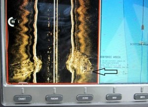
Image 1: A screen shot of the side scan image of the Scottish Prince.

Image 1: A screen shot of the side scan image of the Scottish Prince.

Image 2 : The concentrated magnetometer signal for the wreck of the Scottish Prince (the central red spike).

Image 2 : The concentrated magnetometer signal for the wreck of the Scottish Prince (the central red spike).

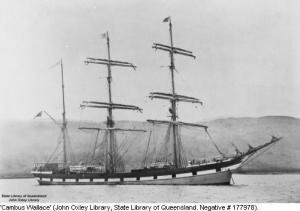
Despite the Cambus Wallace being a larger and slightly later ship, its position closer to the shore and within the prevailing swell has meant that it has suffered considerably more damage and is now broken up. The wreck was relocated in the 1970s and artefacts removed from it; there have also been regular reports from people who claim to have historically fished it and people have regularly fished on it, however its exact position has remained elusive because it is only intermittently exposed and official position references are based on triangulations from land marks that no longer exist. It is also located near the surf zone and Jumpinpin bar, meaning it can only be safely surveyed and dived during westerly winds or in very calm conditions – which occur only periodically.

Image 3: The Cambus Wallace - courtesy John Oxley Library

Image 3: The Cambus Wallace – courtesy John Oxley Library

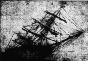
Image 4 : The wreck of the Cambus Wallace just offshore - (Queenslander 14 September 1938 Page 6).

Image 4 : The wreck of the Cambus Wallace just offshore – (Queenslander 14 September 1938 Page 6).

After completing the Scottish Prince geophysical survey, there was sufficient time to conduct a speculative survey for the Cambus Wallace. Interim transects were developed, but the very shallow nature of the environment meant that the skipper was forced to follow the submerged sand bank to avoid risk to the vessel and the mag.

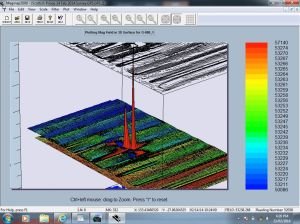
Image 5: The magnetometer signal obtained during the survey for the Cambus Wallace.

Image 5: The magnetometer signal obtained during the survey for the Cambus Wallace.

A strong concentrated signal was located, although the return pattern was not as defined as the Scottish Prince (see Image 5). When the coordinates for the possible Cambus Wallace were cross referenced with historic aerial imagery, a clear darkened shape was intermittently visible approximately 200m from the magnetometer signal. The shape of the object was consistent with the dimensions and reported alignment of the wreck (see Image 6).

Image 6: The darkened shape (marked by the red box) later identified from aerial imagery very near the magnetometer signal.

Image 6: The darkened shape (marked by the red box) later identified from aerial imagery very near the magnetometer signal.

Although yet to be confirmed with a dive inspection, this is a very promising lead that corresponds with historic records and public information.
Although the magnetometer reading is strong and relatively confined, the strength of the signal is not as great as for the smaller Scottish Prince. If the signal does represent the Cambus Wallace, the slightly weaker signal could be indicating that the wreck is closer to shore where the survey vessel could not safely travel; this is potentially consistent with the aforementioned darker shape being the wreck. There is also the potential for the Cambus Wallace site to have a larger debris field, given the dynamic nature of the site environment and the more collapsed nature of the vessel’s upper deck. Certainly there is still work to be done, but if we confirm the signal is the Cambus Wallace, it will be an exciting ‘rediscovery’.

Image

Nice Day for a Fish

The problem with perfect conditions is that everyone has the same idea – let’s get out there! Of course the popular idea of fishing was not the same as ours—i.e. towing a magnetometer fish as part of the Department of Environment and Heritage’s magnetometer trials. The initial focus of the trials was to perfect the hardware and software ‘set-up’ and investigate the detection range and signature profiles for different known wreck types. The four wrecks selected for initial testing were:
1. Tiwi Pearl: a modern fishing trawler sunk as an artificial reef.
2. S.S. Dover: a former ferry converted to a machine gun platform
3. The wheel house of the Captain Nielsen, a suction dredge that capsized in 1964.
4. Grace Darling: a wooden schooner that ran aground in 1894.

Figure 1: Map of Moreton Bay showing the location of the four wrecks used for initial magnetometer testing.

Figure 1: Map of Moreton Bay showing the location of the four wrecks used for initial magnetometer testing.

It took a little while to get the magnetometer and computer configuration working the way we wanted, but we eventually set out only an hour later than expected on a glorious, sunny, calm day. Upon arrival at the starting point of our search grid for the S.S. Dover it was immediately obvious where the wreck was located, as there were three recreational fishing vessels anchored in the middle of the grid. We commenced the survey and as we moved closer to the group, they became increasingly curious about what we were doing. By the time we came in close proximity they were actively enquiring why a Marine Parks vessel was trawling back-and-forth around them. When advised of our intention they freely offered to provide the marks for the wreck if we would immediately leave. Interestingly, the aluminium hulled fishing vessels caused no significant magnetic interference. Fortunately there were no hook-ups or problems on our part, but the final nail in their fishing efforts came with a large pod of dolphins, which also forced us to slow down and recover the tow-fish. Seems like everyone was taking advantage of the great conditions.

Figure 2: A large pod of dolphins passing the vessel during the magnetometer survey.

Figure 2: A large pod of dolphins passing the vessel during the magnetometer survey.

The search for the wheel-house of the Captain Neilsen was based on marks taken during a recreational dive inspection. The site was meant to be located within the centre of the grid to test detection range. However, when we finished the grid we had only a marginal reading in the top N/E corner of the grid. We immediately extended the search in that area and found a strong signature that was confirmed via side-scan sonar to be the wheel house.

Figure 3: The side scan image (left) and vessel track (right) showing the location of Captain Neilsen’s wheelhouse.

Figure 3: The side scan image (left) and vessel track (right) showing the location of Captain Neilsen’s wheelhouse.

The Grace Darling site proved quite problematic due to its shallow depth and proximity to shore. Some of the planned transects were in too shallow water and the alignment of some transects had to be adjusted to suit the topography of the seabed.

Figure 4: A print out of magnetometer readings for the Grace Darling. Note the gaps between positive returns (in red) indicating the transects were too far apart to detect the shallow and highly degraded timber wreck.

Figure 4: A print out of magnetometer readings for the Grace Darling. Note the gaps between positive returns (in red) indicating the transects were too far apart to detect the shallow and highly degraded timber wreck.

The last wreck, the Tiwi Pearl, was again immediately obvious, as there were nearly a dozen recreational fishing vessels in the immediate vicinity. Similar to the S.S. Dover, the fishing fraternity kept a close eye on proceedings as we endeavoured to run transects around them. Again, we found the recreational vessels caused minimal instrument interference. Importantly, we also found the magnetometer worked more effectively when side-on, or adjacent to the wreck, than immediately above it.
The key outcome of the initial testing was greater understanding of the detection capacities of the system and how to configure the surveys. While it was no surprise that the detection range was directly proportional to the depth of target and its ferrous concentration, it was surprising that, for the timber wreck of the Grace Darling, transects needed to be considerably reduced, as there were gaps in the positive signal. While this enabled the results to be pieced together to get an overall picture, it was reliant upon our understanding of the nature of the site and indicated that buried wooden wrecks would require tighter transects to achieve complete coverage.

During post-processing it also became apparent that the way we had configured our searches in the software prevented us from separating out certain finds during post-processing. This meant we needed to repeat some of the searches, which was serendipitous, as the revised search grid for the Captain Nielsen led to the discovery of more large pieces of wreckage nearby. The new information about transect width was also important as it forced us to revise our strategy for the planned search of the Venus. For now, though, the next step is to test the mag on a large historic iron barque and conduct a preliminary search for another of the same configuration lost nearby.

Image

Moreton Bay Magnetometer Survey – Making it Work

By Paddy Waterson

It’s always exciting, and a bit nerve racking, when you get a new piece of ‘kit’.  Will it be easy to put together? Will it work as well as you hoped?  Will it enable you to achieve the results you have promised?  You have probably seen the same piece of equipment at work and know the basics, but the onus is on you now and there are always tricks to be learnt.

In 2013, the Queensland Department of Environment and Heritage Protection invested in a new Geometrics G882 Marine Magnetometer to assist with the Queensland Historic Shipwreck Survey (QHSS). The QHSS is a five year initiative to update official records on the state’s estimated 1400 historic shipwrecks. The size of the state, and the number of historic shipwrecks, means that the fieldwork component of the survey is aimed at locating, identifying and documenting wrecks in key strategic areas, such as Moreton Bay. The initial phases of fieldwork in the QHSS used an existing side scan sonar system and had been quite successful in locating a number of wrecks. However, it soon became apparent that we need something more. The dynamic nature of the Queensland coast made locating many timber wrecks problematic, largely because they are constructed from materials that are extremely vulnerable to deterioration in the marine environment and so tend to have a lower physical profile. This is compounded by Queensland’s offshore environment that is a mixture of dense corals, thick muds and highly mobile sand, all of which can significantly inhibit the effectiveness of visual and side scan sonar searches for low profile historic shipwrecks. A business case for a magnetometer was subsequently developed and the G882 was purchased using funds from the Commonwealth Historic Shipwrecks Program—now I just have to make it work!

A project was developed to configure and test the magnetometer in local conditions to ensure we achieved the best potential outcomes when it was deployed across the state. This project has two phases:

  1. The initial testing of the magnetometer on five known shipwrecks to determine its operational limits and develop a signature profile guide for different wreck types.
  2. Conducting preliminary research into two previously un-located wrecks in the Moreton Bay Region.

The initial testing phase will use five known wrecks within the greater Moreton region. These wrecks were chosen for their comparative signature profile testing, as they are a good representative sample of the different wreck types commonly encountered along the Queensland coast. The test wrecks range in type from a small wooden schooner and a large iron hulled barque, through to steel hulled trawler. By comparing the different magnetic signatures of the wrecks, and their relative detection ranges, we will be able to refine future survey methods and better interpret results when searching for previously un-located historic shipwrecks.

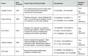
Table 1. Details of the five wrecks used to test the magnetometer, build a signature profile and refine search methods. These wrecks were chosen due to their variation in size, physical profile and construction materials.

Table 1. Details of the five wrecks used to test the magnetometer, build a signature profile and refine search methods. These wrecks were chosen due to their variation in size, physical profile and construction materials.

The initial configuration and preliminary tests were conducted in November 2013. The hardware configuration for the magnetometer was relatively simple, as it came correctly calibrated for the region. Some minor assembly was required, but this was quickly achieved with the support of staff from Marine Sciences and the Queensland Parks and Wildlife Service.

The Geometrics G882 Marine Magnetometer

The Geometrics G882 Marine Magnetometer

The magnetometer being deployed from the Queensland Marine Parks vessel Caretta.  Assisting are Ranger Rohan Couch (left) and Technical Officer James Fels (right).

The magnetometer being deployed from the Queensland Marine Parks vessel Caretta.  Assisting are Ranger Rohan Couch (left) and Technical Officer James Fels (right).

The initial software configuration proved more challenging, as the magnetometer software was configured to integrate the GPS data via a ‘pin-port’ rather than the more common USB connection—this was resolved through the acquisition of an additional ‘pin-port’ aerial output cable.  The use of a specialised laptop that could cope with the movement of the vessel was also essential—many laptops simply lock up the hard drive when vibration is detected.

The laptop, data junction box and GPS configured and ready for deployment.

The laptop, data junction box and GPS configured and ready for deployment.

With the initial set-up and preliminary systems testing complete the surveys of the known wrecks could commence—and a new range of challenges could begin. More on that in my next blog.