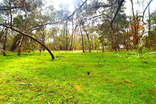
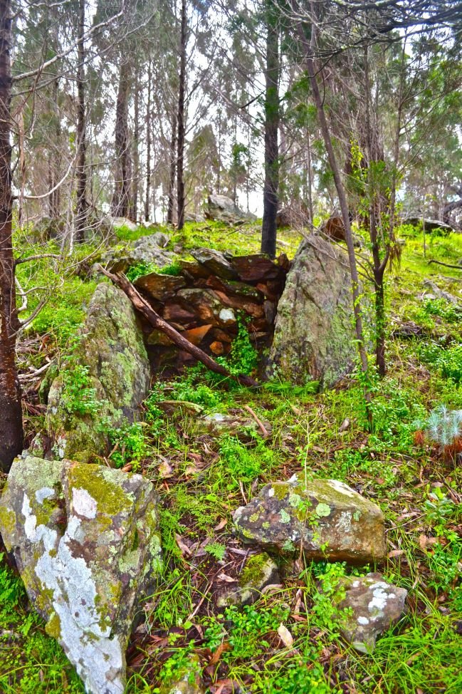
Rockin’ Rocky

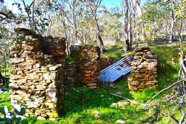
Rocky Hills Ruins

Rocky Hills Ruins

Hi guys, I’ve finished my placement and have had an absolutely amazing time working with Heritage Tasmania during their re-evaluation of heritage listed sites.

One of the sites that I worked on during the re-evaluation was known as Rocky Hills Probation Station, a station that was set up during the 1840s and followed the, unique to Tasmania, probation system.

I began to work on this listing by researching the probation system and the history behind probation stations in Tasmania. This required reading previous reports on the station and examining surveyor and satellite maps of the site.

An issue with this information was that some of the data was not included and resulted in the assumption that there would be limited archaeological potential at the site, which we later learned was an incorrect assumption.

When we arrived on site we were given a tour of the site by one of the land owners. We spent most of the day at this site and as a result we were unable to visit the other properties that also contained the remains of the Rocky Hills Probation Station. At the end of the day another trip was planned, which I was unable to take part in due to my placement finishing.

I found that this trip to Rocky Hills, and this practicum overall, was a learning experience that I would recommend to anyone who has the opportunity!

Rocky Hills ruins 2

Perfect Placement

Last month Heritage Tasmania welcomed me into their office to undertake my placement by contributing to the revaluation of heritage listed sites. Here, I learnt about the inside workings of heritage divisions and what Heritage Tasmania does for the community through the protection of Tasmanian and Australian heritage.

I began placement not fully understanding what the workings of a Heritage division did and I am leaving with a wealth of knowledge on the division’s inner workings and the type of people that contribute their knowledge to the development and protection of local heritage. My host Sherrie-Lee Evans had been amazing during the placement, teaching me about the intricacies of archaeology in heritage and the amount of research, resources, and time that is needed for updating heritage lists within the office.

Of the many things that I learnt one thing that stood out was that Tasmania used both the assignment system and probation system for their convicts, something not explained during my education at University. Therefore, I think that this placement has opened my eyes to the convict history of Australia.

Overall, I believe that this practicum has been one of the most valuable aspects of my archaeology degree and without it I’m sure that I would be worse off. Heritage Tasmania does amazing work for the community and the people within it are inspiring to work with.

Image

The Red Bridge built by convicts.

We visited the bridge to determine if previously recorded boundaries for the protection of the site were accurate.

Photo by John Stephenson.

Fire and Ice

Celeste Jordan

As this year’s excavation in Quinhagak, Alaska, draws to a close, it could not be at a better time. In Area B, permafrost soil appeared midway through the third week and has not melted.  In Area A, it was uncovered on the second last day of excavating in the remaining open squares.  Although permafrost is extremely inconvenient for excavating, it does help to preserve artefacts. Also, in the case of this coastal site, the frozen soil has helped to keep the site somewhat intact from seasonal storms eroding the coast and invariably destroying it.

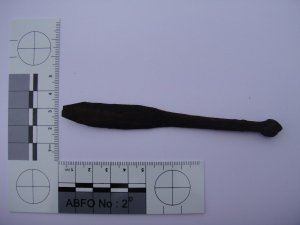
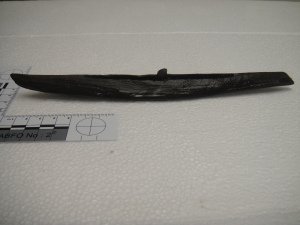
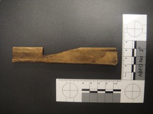
Certainly for me, the more interesting artefacts that have been recovered over the season are those relating to Yup’ik maritime and seafaring traditions.  They might not be the most spectacular but they reveal fascinating information about how Yup’ik regarded the sea, taught children about seafaring lifeways and the development and use of seafaring technologies. With three miniature kayaks, one miniature kayak paddle, sea animal and water fowl effigies (pendants, toggles for harpoon lines, mask attachments and dance sticks), three fishing net gauges, two gut skin scrapers for waterproof overwear for kayak hunters and broken gunwale sections, my directed study has been most fruitful.

Miniature kayak paddle. Photo: Celeste Jordan 2013

Miniature kayak paddle. Photo: Celeste Jordan 2013

Miniature kayak made of wood. Photo: Celeste Jordan 2013

Miniature kayak made of wood. Photo: Celeste Jordan 2013

Net Gauge. Photo: Andrius Kuro 2013

Net Gauge. Photo: Andrius Kuro 2013

This site is wonderfully diverse in terms of the archaeological sub-disciplines it falls under as well.

  • Indigenous archaeology – it is a Yup’ik Eskimo site
  • Pre-historic archaeology – it is pre-contact
  • Rescue archaeology – coastal erosion is threatening the site
  • Maritime archaeology – Yup’ik were/are a coastal community
  • Palaeoecology – including faunal, insect and plant analyses
  • Palaeoclimatology – Sediment and microfossil analyses

There is also a strong community archaeology focus -

  • High school students worked on site as part of a summer employment program
  • Teachers brought students to the site for their Earth Sciences class
  • The project holds a Show and Tell of all the artefacts, in the village
  • It will generate a handbook to assist the community to identify and recover data and material from other threatened archaeological sites
  • Community workshops have been planned that will ensure Yup’ik voices are heard in the project
  • Development of programs and resources will raise public awareness and education, and in particular will be used to develop a curriculum package for young people in schools.
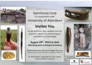
Community invitation to the Show and Tell. Developed by Celeste Jordan 2013, reproduced with the kind permission of Qanirtuuq Corp and The Nunalleq Project

Community invitation to the Show and Tell. Developed by Celeste Jordan 2013, reproduced with the kind permission of Qanirtuuq Corp and The Nunalleq Project

It has been an excellent experience working on a terrestrial site with such varied sub-disciplines and it has given me a greater appreciation for my dirt digging cousins. I cannot imagine how challenging it would be to draw context profiles underwater – it is hard enough if your wall is not straight!

I have also gained valuable insights into the importance and gravity of community archaeology. Not only are children excited by the finds but community members often drop past just to see what we uncovered during the day. There have been a few instances where Elders have been able to shed light on artefacts and their context. However, with some artefacts, like grass matting and cordage, community members are re-learning lost traditions. The Show and Tell is an integral avenue for the greater community to learn and associate with their heritage. It is marvellous that this project is able to enrich community traditions and aid in greater understanding of why things are done the way they are.

So from Quinhagak, Alaska, I shall see most of you very soon.

Polar bear at Anchorage airport. Photo: Celeste Jordan 2013

Polar bear at Anchorage airport. Photo: Celeste Jordan 2013

Let’s get Geophysical! Non-invasive Underwater Archaeological Survey Methods

Trends are not a new concept to archaeology. The patterns found in the archaeological record are what lead to the wider inferences made about past cultures or behaviours. However, the latest trend in archaeology isn’t about similarities in information sets or assemblages,but rather the movement towards in situ (in place) preservation of archaeological sites, especially in underwater archaeology. I use the term ‘trend’ loosely, as it implies that in situ preservation is a ‘fad’ that will become obsolete given enough time or with the arrival of a newer, en vogue concept. I actually believe the opposite is true, that in situ preservation is here to stay and that it is the future of archaeology, above or below the water. This is not so much my opinion, but more of an observation. Looking at the international legislation that surrounds underwater cultural heritage (UCH), one cannot help but see that in situ preservation is pressed as the primary approach (UNESCO, 2001: Article 2,5; UNESCO Annex, 2001:Rule 1) and in many introductory texts, non-invasive survey methods are considered the future (Bowens, 2009:5). We need to know what is under the seabed in order to know if archaeological sites lie beneath, but we are trending away from invasive methods of surveying like subsurface testing. This leaves non-invasive approaches like geophysical surveys and remote sensing.

Geophysics in underwater archaeology is the scientific study of features below underwater and under the seabed using a range of specialized instruments while remote sensing is obtaining images of a phenomena from a distance (Bowens 2009: 217). It is common for these two methods to be grouped together, as they both deal with the ability to collect large amounts of data quickly and understand the scale of the surveyed site without having to be directly on or necessarily near it. In the past, geophysics was used primarily for site prospection but has been applied more recently to research and site management (Bowens 2009: 103). Geophysical and remote sensing surveys allow for the coverage of large areas relatively quickly and economically. They are not meant to replace divers on a site, but aid in timely identification of site locations, site distribution, site boundaries, and sub-seabed phenomena and are particularly useful in environments with poor underwater visibility, strong currents, or any other environmental hazards. Geophysical and remote sensing surveying methods will be discussed and can be grouped into three types: acoustic systems, magnetometers, and submersibles. These methods are used over a large area to ensure complete coverage of the site and its environmental context and are very accurate when used with global positioning system (GPS) satellites and differential global positioning system (DGPS) land-based reference stations. Using both will increase site position fixing as DGPS makes range corrections for GPS satellites; the addition of an on-boat GPS antenna increases accuracy (Bowens 2009:94).

Acoustic Systems:

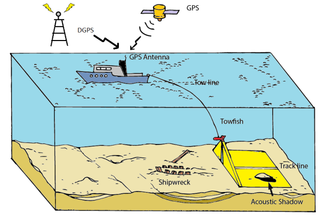
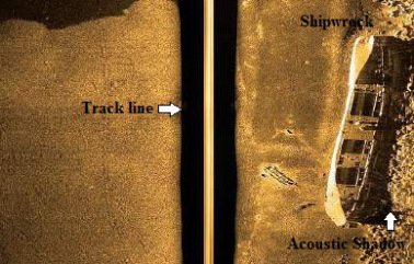
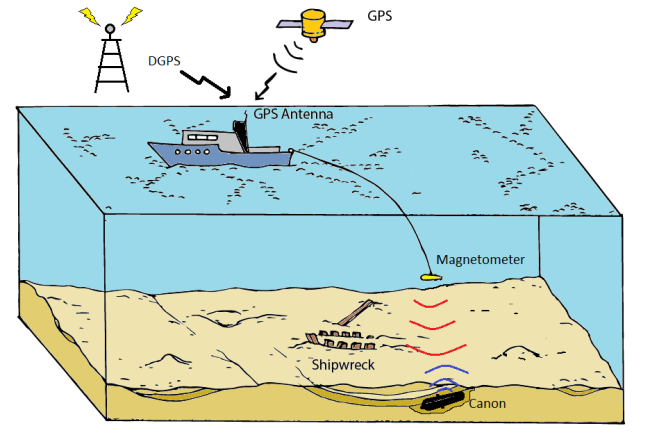
These systems are the most commonly used geophysical method for underwater archaeological surveying. Sonar,or sound waves, are used in order to obtain the desired information. Some forms of acoustic surveying systems are: echo-sounders, multibeam sonars, side scan sonars, and sub-bottom profilers (Bowens 2009:104). The general idea behind these types of non-invasive systems is to use reflected sound waves (echoes) to construct a picture of what the underwater site and bathymetry, or depth over seabed, looks like.  Figure 1 shows the different components and general setup for using side scan sonar. Side scan sonar uses a wide-angle pulse of sound (emitted from the towfish) and the strength of the reflected scattered sound to display an image (Figure 2). The coverage of the side scan sonar can reach over 100m on either side of the track line. The track line is a gap in between the two sides; its size varies by size of coverage and depth. It is a ‘dead space’ of sorts where there is too much interference between the two sides to get an accurate image. This problem can be countered by overlapping boat runs to ensure full coverage. Acoustic shadows are also important as they can give a general description of objects that sit proud (vertical) to the seabed (Bowens 2009:108), see Figure 2.

Image

Figure 1.  The components and set up of a side scan sonar (image created by author)

 Image

Figure 2. The results of a side scan sonar survey (after Kainic 2012)

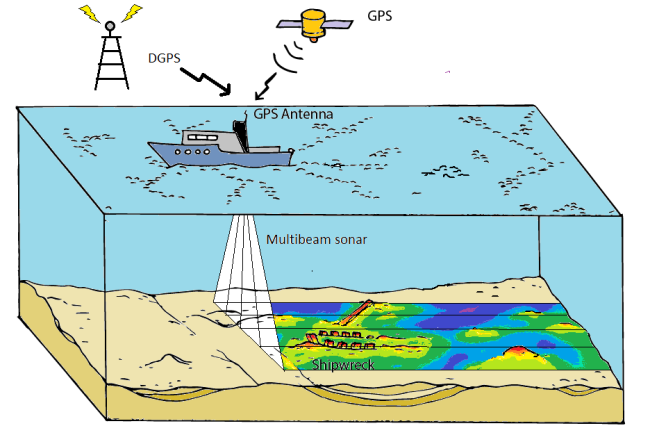
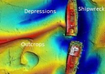
Echo-sounders and multibeam sonars are generally used to gauge vertical measurements or depth. Echo-sounders were first to be applied to maritime archaeology and used a single transceiver to send an acoustic pulse straight down to the seabed and read the reflection or echo on a single prescribed spot. Multibeam sonar (also known as swath bathymetry) records a continuous thin strip of depth directly below and to the side of the boat (Figure 3), effectively scans the surface of the seabed, and creates a 3D image via colour gradations to highlight depressions and outcrops, as represented in Figure 4 (Bowens 2009:106). Sub-bottom profiling is the only means to locate buried wooden material culture underwater; metal material culture will be discussed in the next section. Strong short pulses of sound are shot into the seabed sediment and ‘reflect’ anything that sends the echo back earlier than the rest. The two forms of sub-bottom profiler are single-frequency pulse (also known as ‘pingers’ and ‘boomers’) and swept-frequency pulse (‘chirp’) (Bowens 2009: 109). Using both devices ensures the best coverage and penetration of the seabed.

 Image

Figure 3. The setup of a multibeam sonar survey (image created by author)

 Image

Figure 4. The results from a multibeam sonar survey, red are closer to the surface while blue is deeper (after Cox 2012)

Magnetometers:

Magnetometers measure the strength of the earth’s magnetic field and are used to detect the presence of ferrous material (iron) by the variations they cause in said field (Bowens 2009:111). This may include both man-made objects, like the cannon in Figure 5, or geological formations. They are usually deployed in a towing array to inhibit interference from the tow boat and the data they collect are plotted (or ‘contoured’) according to varying magnetic intensities (Figure 6).

 Image

Figure 5. The setup of an underwater magnetometer survey (image created by author)

 Image

Figure 6. The results of a magnetometer survey (Spirek 2001: Figure 2)

Submersibles:

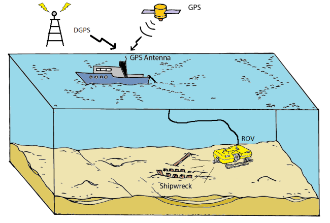
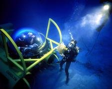
Submersibles for archaeological surveying come in three forms: remotely operated vehicles (ROVs), autonomous underwater vehicles (AUVs), and manned submersibles. They can perform many tasks including visual assessments or searches, and photography, thereby negating the need for divers in the water (Bowens 2009:112). ROVs are piloted from the boat and can be outfitted with an array of data-collection devices like acoustic systems or video recorders (Figure 6). AUVs can be outfitted with these devices as well, but are not piloted nor are they attached to a vessel. Manned submersibles can complete the same aforementioned tasks but with an on-board pilot for more control and precision. manned submersibles fall into three categories; commercial, tourism, and research (Kohnen 2005:121).  (Figure 7).

Image

Figure 6. The setup of a remotely operated vehicle (ROV) (image created by author)

 Carolyn sub

Figure 7. The Institute of Nautical Archaeology’s (INA) manned submersible Carolyn in operation in the Aegean Sea (Kohnen 2011)

We know that the goal is to try to leave the archaeological site in its original context, as well as the best non-invasive ways to survey it, but why go through all the trouble? As archaeology is an ever changing field that progresses in parallel with new technology, it is undeniable that the information we gather ten years from now will be of a higher quality and degree of accuracy than what we collect today. This means that whatever we choose not to disturb today may never need to be disturbed in the future. Yet we must still yield a high degree of archaeological data,and therefore non-invasive survey methods, like those mentioned above, are an investment for our future AND our past.

References

Bowens, Amanda (editor)

2009 Underwater Archaeology: The NAS Guide to Principles and Practice. 2nd ed. Blackwell Publishing, West Sussex.

Cox, Marijke

2012 Building an Estuary Airport Close to Sunken Warship Branded ‘Bonkers’. Electronic document, http://www.kentnews.co.uk/news/building_an_estuary_airport_close_to_sunken_warship_branded_bonkers_1_1416102, accessed 30/08/2013.

Kainic, Pascal

2012 Search and Recovery Side Scan Sonar. Electronic document, http://www.yousaytoo.com/search-and-recovery-side-scan-sonar/1924787#:image:2729577, accessed 30/08/2013.

Kohnen, William

2005 Manned research submersibles: State of technology 2004/2005. Marine Technology Society Journal, 39(3): 121-126.

Kohnen, William

2011 Carolyn‘s 10-year Aegean voyage for INA. Electronic document, http://nauticalarch.org/news_events/news_events_archives/prior_to_2011/carolyn_takes_a_break/, accessed 01/09/2013.

Schott, Becky K.

2013 The Wrecks of Thunder Bay: A Photo Essay. Electronic document, http://www.alertdiver.com/m/?a=art&id=780, accessed 30/08/2013.

Spirek, James

2001 Port Royal Sound Survey: Search Begins for Le Prince. Legacy, 6(2):28-30.

UNESCO 2001 Convention for protection of underwater cultural heritage.

The South Australian Archaeology Database Now Complete

Apologies to all who have been following my Directed Study blog posts and have realised I’m yet to write my fourth and final blog. Due to working on a dig here in the UK in a remote area, very limited access to the internet and a busy working schedule I have finally gotten around to completing the South Australian Archaeology Database and report.

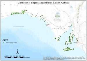
The database project started way back in March, with the aim of creating a user-friendly and publicly available database of Indigenous archaeological sites located along the South Australian coastline. After several trips to the South Australian State Library, and hours spent looking through journals online, the archival research phase of the project uncovered 347 archaeological sites. The sites were found across the Adelaide Plains, Yorke Peninsula, Eyre Peninsula, west coast, Nullarbor Plain and Kangaroo Island.

db

Figure 1 – Example from Database

Once the database had been compiled and edited to a professional standard, the next phase of the project was to create a spatial distribution map in ESRI ArcGIS 10.1©.

map

Figure 2 – Spatial Distribution Map of Sites

As the database and map were both being constructed, general patterns started to emerge in the data, which formed the basis for the analysis of the data. The aim of the analysis was to determine how South Australian Indigenous archaeology fit into the continental narratives of prehistoric Australia, and what the current gaps in the archaeological record of the region were.

Using ArcMap and ArcCatalog software, site distribution patterns, proximity analyses in relation to site distances from the coast and water courses, environmental context investigations and colonisation model conformity based on dated sites were undertaken and revealed some intriguing and useful information on the archaeology of South Australia.

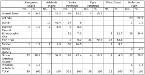
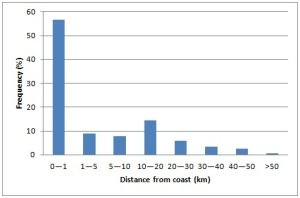
From the results, it could be seen that some site types were only found in certain geographic regions, while others, such as stone artefact scatters, were found in great numbers across the entire study area. Large proportions of sites were found to be within short distances of both the coast and of fresh water courses. Many sites were also located in protected areas of current-day land zones.

table

Figure 3 – Site types per geographic region

graph

Figure 4 – Site frequencies and distances from coast

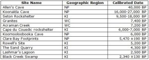
Only 12 of a possible 347 sites provided reliable dates, from which some minimal conclusions could be drawn as to how the study area fits into colonisation patterns, and more dates would need to be determined in order to make definitive concluding statements. The results disagreed with both Bowdler and Horton that settlement was along coastal areas before moving into central Australia, but conformed closely to Veth et al’s (2011) colonisation model of simultaneous settlement of all habitats through information exchange.

dates

Figure 5 – Dated sites from project in chronological order

The database stands to be a key addition to the current archaeological record for South Australian archaeology as it has pulled together all the accessible publications available for the state into one, easy to use database. There were a large number of restricted survey reports and journal articles that would have helped to create a more complete database for South Australia, but this project has constructed a sound foundation to build upon.

Getting Shipshape: Assessing Shipwreck Significance

Jane Mitchell

Significance adj. the quality of being significant or having a meaning
(The Macquarie Dictionary 3rd edition)

The project I’m working on aims to evaluate current statements of significance for those Victorian shipwrecks that have associated artefacts collected by Heritage Victoria.

The Heritage department is about to embark on an assessment of the significance of its shipwreck artefact collection. In light of that, it is especially important the shipwrecks the artefacts came from have sound statements of significance to provide a framework for the assessment of the collection.

The significance of particular items of cultural heritage will mean different things to different people … and over time what is considered important can also change. A thorough significance assessment is critical in properly understanding the meaning and value behind an item and is the foundation on which all management plans should be built.

Maarleveld et al. sum up the problem nicely: like beauty, significance cannot be defined in legal terms (2013: 83). However, any subjective opinion must be removed as much as possible. Therefore, methods for assessing significance have been developed for use by managers responsible for items of cultural heritage.

Assessing Significance

There are various methodologies for assessing significance but all have the same central process:

  1. Research the history of the wreck including its history since sinking.
  2. Compare and assess against a defined set of criteria.
  3. Write a statement that distills the essence of a wreck’s significance into a sound bite that encapsulates as much as possible.

burra charterThe cornerstone of Australian heritage practice is the Burra Charter (the Australia ICOMOS Charter for Places of Cultural Significance) first adopted in 1979. Government legislators and funding bodies give preference to work that follows the processes and approach of the Burra Charter (Marquis-Kyle & Walker 2004:6).

The charter uses five values to define cultural significance: aesthetic, historic, scientific, social and spiritual. These criteria are always listed alphabetically and one is not considered more significant than another.

The Australian Institute of Maritime Archaeology’s (AIMA) Guidelines for the AIMA GuidelinesManagement of Australia’s Shipwrecks (1994) is the only Australian publication that deals specifically with assessing significance for shipwrecks and uses eight criteria to do so:
  1. Historic
  2. Technical
  3. Social
  4. Archaeological
  5. Scientific
  6. Interpretative
  7. Rare
  8. Representative

The last two criteria are considered comparative and allow the significance of a wreck to be placed into a broader context, thereby fixing its place into the wider cultural landscape.

Reference must also be made to the Guidelines for Investigating Historical Archaeological Artefacts and Sites, published by the Heritage Council of Victoria in December 2012. The Council has updated its eight criteria, which are different to, but encompass the same ideas as, the AIMA criteria.

It should be noted that, whatever criteria are used, not all of them must be met for a wreck to be deemed significant. It should also be remembered that significance could change over time and as such needs to be revisited and revised regularly.

The Victorian scene

All information relating to shipwrecks in Victoria are registered in the Victorian Wreck register. The register contains fields for the physical attributes and locations of a wreck and allows uploading of any images, surveys and management plans. There is also a field for Statement of Significance. A quick database search of all shipwrecks reveals that, out of 705 registered shipwrecks, 252 have been located and of those, just under half have significance statements attached to them.

All wrecks on the Victorian Heritage Register with or without a Statement of Significance

All wrecks on the Victorian Heritage Register with or without a Statement of Significance

In Victoria, either the Commonwealth Historic Shipwrecks Act (1976) or the state Heritage Act (1995) provides protection to shipwrecks. These pieces of legislation give blanket protection to all shipwrecks and relics that are 75 years and older – whether their location or existence is known or not. This implies an inherent level of significance to a wreck or relic without the requirement to demonstrate it.

Wrecks 75 years or older with or without Significance Statements

Wrecks 75 years or older with or without Significance Statements


Project scope

My Directed Study project is starting with an assessment of 18 shipwrecks that Heritage Victoria has been involved in excavating and/or has collected artefacts from. These include well-known wrecks such as Loch Ard and SS City of Launceston and other lesser known ones such as Foig-a-Ballagh. There is even one existing under reclaimed land: HMVS Lonsdale.

Victorian Shipwreck list

The 18 wrecks of this assessment project. Note: EMu is the collections database and numbers indicate the number of artefacts held in the collection for each wreck.

A quick review of the information in the database for these 18 wrecks has revealed that 15 have Statements of Significance.  So now we know the quantity, what about the quality?

The statements of significance range from a short paragraph to one sentence. Compare Loch Ard:

The Loch Ard is historically significant as one of Victoria and Australia’s worst shipwreck tragedies. It is archaeologically significant for its remains of a large international passenger and cargo ship. It is highly educationally and recreationally significant as one of Victoria’s most spectacular diving sites, and popular tourist sites in Port Campbell National Park.

To HMVS Lonsdale:

HMVS Lonsdale is historically significant as a relic of Victoria’s colonial navy.

There is no breakdown of the assessment criteria for any of these wrecks in the database. While this information may be in conservation or management plans, these are not necessarily uploaded into the database. There is also no date so it is impossible to ascertain when the statement was written.

As I’ve searched through the database and researched the nature of significance I am struck by the thought that this lack of detailed information has been created in part by the very pieces of legislation designed to protect the wrecks themselves.

Blanket protection, which assumes a level of significance of all protected wrecks, does not require significance assessments for a wreck to be entered in the register. Currently, wrecks are being protected based solely on age, as others that may have more significance are decaying. However, as resources are limited in the current economic climate, priorities need to be in put in place. Significance assessments are an important part of that process.

In most cases, shipwrecks are intangibly tangible relics from the past. They exist out of sight under the water and are visited by relatively few. Underwater cultural heritage managers need to provide solid significance assessments, that are readily available and easily accessible. Only then will we be able to put forward a credible case for sufficient funding to preserve our shipwreck heritage. Hopefully this project will be a start to that process.

You can read about how I used the criteria to write a statement of significance for HMVS Lonsdale here.

What are your thoughts on assessing significance of shipwrecks? How do they differ from terrestrial sites? I’d be really interested in your opinion.

References

Australia ICOMOS 1999 The Burra Charter: The Australia ICOMOS Charter for Places of Cultural Significance.

Australian Institute for Maritime Archaeology. Special Projects Advisory Committee & Australian Cultural Development Office & Australian Institute for Maritime Archaeology 1994 Guidelines for the Management of Australia’s Shipwrecks, Australian Institute for Maritime Archaeology and the Australian Cultural Development Office, Canberra.

Marquis-Kyle, P. & M. Walker 2004 The Illustrated Burra Charter. Good Practice for Heritage Places. Australia ICOMOS.

Maarleveld, T.J, U. Guerin and B. Egger (eds) 2013 Manual for Activities Directed at Underwater Cultural Heritage. Guidelines to the Annex of the UNESCO 2001 Convention. UNESCO Paris.
The Life of the Lady Alice Mine

Image

(Building remains)

Here we are once again. I’d like to invite you back to read about my second semester Directed Study on the Lady Alice Mine (continued).

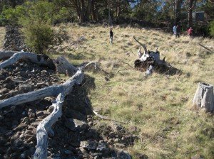
This semester I will be looking more closely at the domestic side of the Lady Alice. It is clearly evident when you visit the site that there are many buildings that were once used for the mine, but where did people live whilst they were working on the mine? We know that the mine’s operations were on and off from 1871 to 1931 when it eventually closed.

On the 21 of July my Industry Partner, Dr Cameron Hartnell and I went out to the Lady Alice Mine so that he could show me the domestic side of the mine. As we made our way to the site, we stumbled upon a possible tent site with an animal pen.

Image

(Photo of site 1A, looking North)

It is hard to see from this photo, but in front of the bent tree is a shallow trench. This could have been one side of a fence. On the other side of the tree is a slight ridge where a temporary tent or hut would have stood. At the bottom of this site is a mine shaft. We were unable to predict how large the shaft was, as at the time it was filled with water.

To the left of the photo below was another site where we found remnants of a hut. This could have been a temporary sleeping site for a miner. The site is connected to the first site by a clear path. Image

There are buildings that still stand in the vicinity of the mine and we know the uses of these buildings. We know that there was a school, a captain’s house and a local pub. In newspaper articles, we know that James Goddard lived in the area until his death. By doing this study, we hope to get an insight into how and where people lived in association with the Lady Alice Mine, so stay tuned for more insights into the unravelling of the domestic life of the Lady Alice Mine.