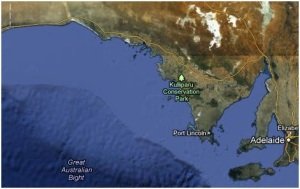
New project study area (source: Google Maps)
Since my last post the wheels have started turning and my directed study has started to gather some momentum. My aim for this project is now not only to create a publicly accessible database on coastal Indigenous sites in South Australia, and produce a subsequent map, but to then use the data collected as a predictive model to analyse where sites can be found and why they might appear there. Another aim is to establish where there are gaps in this sort of knowledge in South Australia, and determine where more extensive work could be carried out in the future.
After a few more meetings with Mick Morrison to discuss necessary information on sites for the database, and countless hours spent in the State Library fossicking through survey reports and sometimes quite old pamphlets, my database appears to be complete. In total, I came across 327 documented sites from Kangaroo Island (now included in the study area), the Adelaide Plains, Yorke and Eyre Peninsula’s, the West Coast and the Nullarbor Plain. The fields of data chosen to include in the database were based on Ulm and Reid’s (2000) ‘Index of Dates from Archaeological Sites in Queensland’, which basically did what I am currently doing, but for the whole of Queensland. This survey is where the idea behind my current research project has come from.
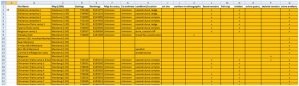
Excerpt from database
Another key component of this project is the map, which is created from the data collected. The idea here is to create a basic map in ArcGIS with the site locations included and overly this on a basic map of South Australia with several environmental, hydrological and geological layers to help in my eventual analysis of why sites are where. One of the problems I have run into with the map at the moment is the fact that only very few of the 327 sites, have provided locational data that can be transferred accurately to a GIS. Some of the grid references that were provided on certain sites do not fit accurately with a GIS as can be seen in the map I have begun creating below:

The yellow points represent sites that should be on the Nullarbor Plain
There have been some success stories, particularly with the Yorke Peninsula sites and locational data. One survey report on the area contained a map of the region with previous archaeological surveys drawn in. After mapping the sites mentioned in the survey, the resulting map correlated very well with areas that had been surveyed previously, proving that the co-ordinates collected at the time were very accurate.
|
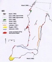
Previous survey studies (source: Wood & Westell 1998)
|
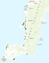
Mapped sites
|
By my next post I intend to have my database published to a professional standard and can start critically analysing the data present. I am also aiming to have my map completed with all 327 sites included, which will assist in the analysis of the archaeology of Indigenous coastal sites in South Australia.
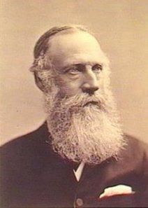
 then, it can be difficult to define exactly how you should go about explaining a person’s life and achievements. So, what I want to achieve would be to articulate both the public perception of the man and also the historical perception to see how they compare to each other. This will hopefully show a more unbiased view of the man and what he has done for South Australia.