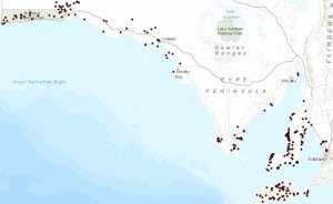
Figure 1 – Site locations across study area
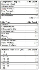
After weeks of scanning survey reports for sites, and hours spent with my head in books reading up on archaeological sites in my project study area, my database is now complete. From my research, the Nullarbor Plain, West Coast, Eyre Peninsula, Yorke Peninsula, Adelaide Plains and Kangaroo Island contain a total of 347 sites that lie within 50km of South Australia’s coastline. My aim now is to extract as much information about the sites in the area and begin to analyse the distribution of these sites. My main objective is to determine why sites appear where they do, where there are gaps in the record and why sites don’t appear in some geographical areas. Some basic data has already been gathered and is shown below:

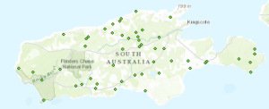
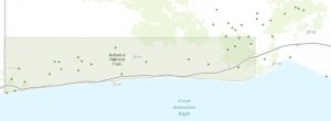
Now that I have gathered all the locational data for the sites, I have been able to display them on a map to see the spread of archaeological sites across the region. From the maps below, you can see that there is no real trend in how sites are distributed across each region. Kangaroo Island appears to have an even spread of sites, both along the coast and inland, while the Nullarbor and Adelaide Plains sites are predominantly found inland. Sites on the Eyre Peninsula and west coast are almost entirely found on the coast or very close to it, while the distribution of sites on the Yorke Peninsula is mostly on the coast, but with many of them further inland.

Figure 2 – Distribution of sites on Kangaroo Island

Figure 3 – Distribution of sites across Nullarbor Plain
It is very basic observations such as these that will help me to conduct more in-depth analyses about site distributions. It may be the case that areas with sites predominantly along the coast are made up of only midden and fish trap sites, which would lure me to investigate whether landform types are having something to do with the lack of inland sites. These answers will hopefully be answered for my fourth and final blog post in a few weeks.

